Woods Map is a powerful GIS project portal and spatial data visualisation platform, supporting both 2D and 3D data. It plays a key role in integrating and delivering our projects and services.
Designed for accessibility and collaboration, Woods Map enables secure sharing of large-scale GIS data across stakeholders. Woods Map portals are designed to support complex projects by bringing data and insights together in one easy-to-access location. Once set up, these secure portals can be shared across teams and stakeholders, and tailored to fit your project workflows and information needs.
Depending on the level of customisation and data volume, portals may be included as part of a project or available through a monthly subscription.
01
Mobile app-based asset inspection visualisation
02
Land development: 2D/3D views of infrastructure, earthworks, models, photos, stages, and linked docs
03
Reality capture: Mesh models in spatial context
04
BIM models: Scan-to-BIM with attributed spatial context
05
Mobile laser scanning: Dense point cloud visualisation
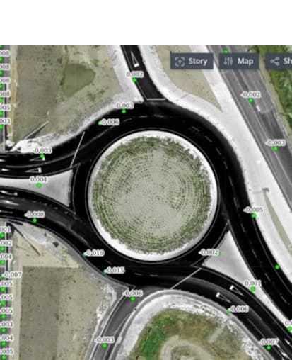
06
Pavement monitoring: Charting, raster analysis, and vector switching
07
Campus model: Mesh and terrain models, vector/masterplan overlays, 360 imagery, media, drone views
08
Nationwide infrastructure management: Assets by chainage, 360 imagery, linear data, and photo-linked assets