The Woods Geospatial Services team are on a mission to enable complex transport, infrastructure and land development projects across New Zealand.
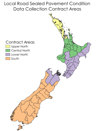
In 2024, the team secured a major NZTA Waka Kotahi contract (Consistent Condition Data Collection, or CCDC) to undertake high resolution mapping of 50% of all New Zealand local roads - Central North and Lower North (excluding state highways).
Aligning with the Road Efficiency Group’s initiatives, Woods’ involvement in this vital project is helping to shape better, more connected communities across New Zealand.
Our Role on CCDC
Our Hamilton Geospatial experts will be leading the work on this project, doubling in staff size over the past 6 months to be able to timely deliver the project.
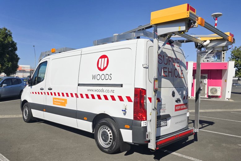
The project will be capturing and processing 100’s of terabytes of data every year. A massive logistical programme is required to enable 7-days a week data capture with field crews rotating to and from the survey vehicles located around the country.
A big focus for Woods is ensuring the health and wellbeing of the crews undertaking the work is maintained. This is all achieved while driving at regular speed limits, meaning that a vast amount of information can be captured in a highly automated and efficient manner, without crews needing to be working in dangerous environments outside the vehicle.
Why is CCDC Important
This contract is the first of its kind in New Zealand; one of the first countries in the world to adopt a nationwide integrated approach to capturing information about roads.
Having consistent information about the quality of New Zealand’s roading enables central and local governments to make more informed decisions about where and how to invest in road maintenance and remediation activities.
Over the last four years 1.5 billion dollars was spent on road sealed maintenance service, re-surfacing and rehabilitation. The data we collect will help local councils improve:
- Lifecycle asset management
- Benchmarking
- Performance management
- Investment decision making.
This data is a critical indicator for NZ’s land and road conditions and is imperative to comparative reporting, research, and fatal crash investigations.
CCDC leverages world-leading Laser Crack Measurement System (LCMS-2) technology to enable the detection of a range of pavement attributes and defects including cracking, potholes, rutting, texture, bleeding, shoving, ravelling, and roughness.
Part of a Bigger Focus for Transport Solutions
The capabilities and experience derived through delivery of the CCDC contract is part of a broader Woods Geospatial focus on transport solutions.
In addition to being able to assess pavement quality, the team also have the capability to assess pavement strength (using Falling Weight Deflectometer technology), as well as high precision survey-grade mapping of road corridors using our Mobile Laser Scanning (MLS) technologies.
Woods is also uniquely placed to be able to locate and map the presence of underground services in large scale roading corridor environments, with its Ground Penetrating Radar (GPR) based solutions.
Woods prides itself on its quality and its “Simply Done Well” ethos. With our Geospatial Services offering one of the most advanced, high precision transport mapping and modelling services in the country, we can certainly live up to this expectation.